Tuesday, June 28, 2016

Kenai Peninsula, June 23 - 27, 2016, Days 53-57

Turnaround Arm, Kenai Peninsula
“In June 2000, Alaska’s Seward Highway, linking Anchorage with Seward, was designated as an All-American Road, an honor reserved for only the most outstanding highways in the nation.  The overall scenic, recreational, cultural, historic, and geologic qualities of the highway corridor are virtually unmatched anywhere.  It is simply one of the world’s great drives.” America’s Byways

Leaving Anchorage journeying to the Kenai Peninsula, Turnagain Arm on Cook Inlet is enveloped by colossal peaks so steep that only vines and shrubs can gain a foothold and even these disappear from the rock and snowcapped peaks.  The Chigmit and Chugach Mountains bolt from the valley
Tunnel to Whittier
floor so precipitously and with such grandeur that the spectacle leaves the traveler incredulous that such beauty can exist.  The entire landscape is stunning and exhausting…there is too much beauty to absorb.  One magical spot after another…
Whittier, where one travels through a one-lane 2 ½ mile tunnel to arrive at this little town at the head of the Passage Canal on Prince Edward Sound, is nestled in among stately mountains that line the Canal.  Twenty Mile Glacier greets the traveler on the left as they exit the tunnel, the Sound is directly ahead, and mountains ring the entire setting.  BEAUTIFUL!!
Town of Whittier
Granite Creek and then Bertha Creek were our basecamps and homes for five days before moving on to Porcupine Campground in the little town of Hope.   There were no amenities at any of these sites thus no blog, cellphone coverage (our daughters were certain that we were dead), but the beauty of the area was the only amenity needed.  Hope, a small town at the end of one of the roads, seems straight out of the TV setting of “Northern Exposure.” A little CafĂ©, featured in this television series, sits picturesquely alongside the road.  Hope was destroyed by an earthquake in 1964 (9.2 on the Richter Scale) and what the earthquake didn’t get the
Passage Canal...overlooking the Whittier Area
resulting Tsunami did.  Game is plentiful in this area, especially bear, and the Kenai campgrounds are a jumping off point to the Russian River where salmon runs occur at frequent intervals…it is here that fisherman are fishing, and bear are fishing as well along with the inevitable encounters.  Salmon, and hopefully not fishermen, are a major food source for the grizzly (brown bear per Alaskans) and one of the reasons that bear are so much larger here than in Denali…far more protein in their diet.  The bear’s diet in Denali consists of 80% vegetation whereas those that can access the salmon runs are less dependent upon vegetation.

River Flowing into Whitttier

Kenai Pond
Granite Creek Campground


                A visit to the town of Homer and it is back toward Anchorage where we will cut across on the Glenn Highway to connect to the Richardson Highway in order to visit Valdez.  This is the southern terminal of the 800-mile Trans Alaska Pipeline that originates in Deadhorse/Prudhoe Bay far to the north.  Valdez, situated in a “majestic fjord where the 5000-foot-tall Chugach Mountains rise from Prince Edward William Sound” was all but destroyed in the 1964 earthquake.  One of Alaska’s many pristine sites, it is often referred to as Alaska’s “Little Switzerland.”  It is here where Exxon Valdez ran aground in 1989 spilling millions of gallons of oil that set off a storm of environmental repercussions both in Alaska and elsewhere in the country.  With heavy dependence on tourism, fisheries, and oil, Valdez was heavily impacted by the resulting environmental fallout.  It will be interesting to hear the perspective of the residents as they relate to this event.  We will share what we learn.
Bear abound in this area
Elk were introduced...like deer, this is not their area
Wood Buffalo have been reintroduced
Hummm....I wonder what there is to eat...maybe a hiker?...or a biker?...meals on wheels....

Scenes along the Kenai...


Sunday, June 19, 2016

Denali National Park and Preserve, June 13 - 16, 2016, Days 44 – 47

At last, the native name for this spectacular mountain has been restored.  Denali, Athabascan for “the high one” was named Mount McKinley in the late 19th century by William Dickey, a gold prospector, who admired President-elect McKinley.  Although McKinley had no connection with the mountain, the name was popularized after his assassination in 1901.
 “The Indians who lived for countless generations in the presence of these colossal mountains have given them names that are both euphonious and appropriate…Can it be denied that the names they gave to the most imposing features of their country should be preserved?” Sheldon, The Wilderness of Denali
South view of Denali

No sooner do we come to the conclusion that we have observed nature at the pinnacle of its beauty then we are yet again astonished.  Denali knocked us back on our heels!  We arrived at Denali amid inclement weather and the surrounding mountains were concealed from view.  The scenery we could see from our RV was beautiful enough.  The silty Nenana River had transformed into a translucent boiling caldron as we approached Denali National Park and the gorge took near vertical drops as it merged with the river below.
 
Our home 29 miles inside Denali Nat. Park
Arriving at the junctions between Denali National Park and Parks Highway was a shock.  Commercialism at its worst!  Not to worry as we traipsed through this, dropped off our dinghy, and proceeded into the park where we had reservations at Teklanika River Campground situated 29 miles inside the park.  A minimum stay of three days is required and only vehicles with reservations are allowed this far into the park all in an effort to minimize traffic and maintain as pristine environment as possible.  There are shuttle buses that, for a reasonable one-time fee, carry visitors another 60 miles beyond Teklanika River Campground in order to observe game, hike in the wilderness, or even bicycle (most buses have bicycle racks).  On day one inside the park, clouds obscured visibility but plenty of game was observed.  On day two and three the skies opened in all their glory with the entire Alaska Range was within view.  Mt. Denali was clearly visible from all angles and there was not a cloud in the sky.  This, I’m told, is most unusual and a rare gift.  Taking the bus to Wonder Lake, approximately 90 miles inside the park, we were treated to bear, caribou, moose, and Dall sheep sightings.  Wolves, wolverines, and lynx are residents as well but it takes more luck than we possessed to see them in this, their natural setting.
Denali from the North Side


Without a doubt, Denali National Park and Preserve with its natural beauty, abundant wildlife, and truly wild habitat have marked this as one of the major highlights of our trip so far.  I will let the pictures display the wonders of this area as I’m at a loss for words to adequately convey the wonder of this pristine setting.

When Denali hides in the clouds
Road into Teklanika Campground

Dall Sheep find safety on the high peaks

Moose abound in Denali Nation Park and Preserve
Bear are everywhere...this one is taking a nap on the hillside
Yet another, looking for something to fill the belly
This guy was CLOSE!!
Spotted a herd of more than 100 caribou within the Park
Caribou have crashed in numbers and studies are ongoing to determine if this is abnormal or a 40 year cycle


Wonder Lake sits 85 miles inside Denali

"We need the tonic of wilderness...At the same time that we are earnest to explore and learn all things, we require that all things be mysterious and unexplorable, that land and sea be indefinitely wild, unsurveyed and unfathomed by us...We can never have enough of nature."  
Henry David Thoreau
Walden:  Or, Life in the Woods

Saturday, June 18, 2016

Denali ZAMP Solar Panel Evaluation June 13 - 16, 2016 Days 44 – 47

 Denali is Athabascan meaning “the high one.”
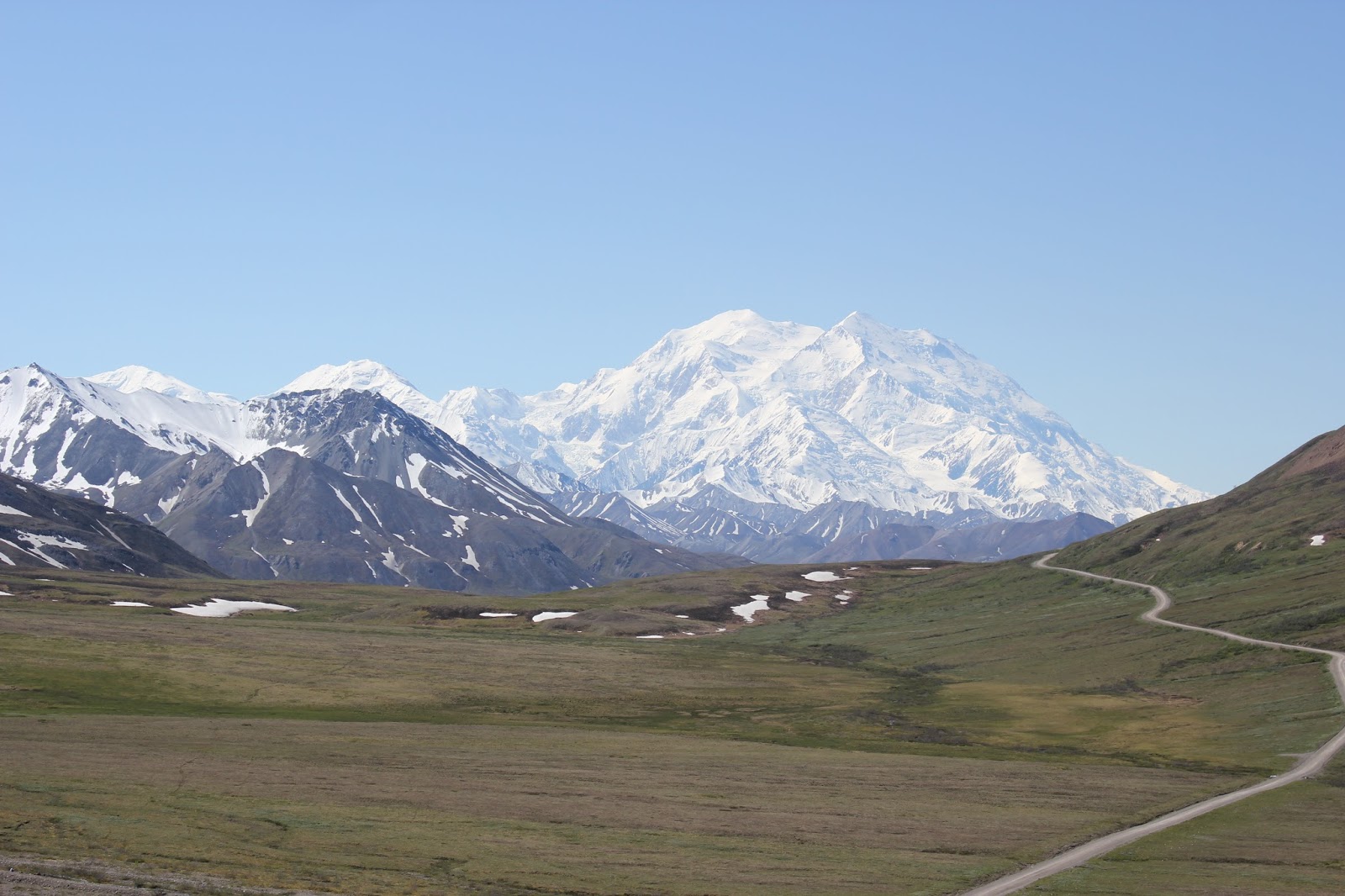
Denali in all of its grandeur
“Denali serves as a barometer for change.  As permafrost thaws, glaciers shrink, and tree lines rise, we feel humbled to care for this living laboratory that is so critical to understanding the effects of climate change on our global community.”
Don Striker, Superintendent, Denali National Park and Preserve

A serious challenge when visiting the upper reaches of British Columbia, the Yukon, and Alaska is that the most beautiful settings are in Provincial, State, and National Parks.  Traveling in May and June we have experienced cold night temperatures that have necessitated hard use of our 12 Volt Suburban Furnace.  Such use can drain the house batteries
Solar Panel in acation
quickly without the availability of shore power or using the generator.  Primitive provincial, territorial, state, and national campgrounds often do not have electrical hookups and severely limit the hours of generator use.  This can make for very cold nights unless there is a means to keep the house batteries charged.  This is where our ZAMP 160 Watt System has been a great addition to our charging system.

With use of the solar panel the challenges have been that many of the days have been cold, wet, and overcast limiting the solar panel’s efficiency.  On the plus side we have 20+ hour days with which to work.  Between generator use during permissible hours and solar power during off hours, we have not had to withstand a cold night without heat.  Before we had solar panels our house batteries limited our stay, in primitive campgrounds, to two days if we started out with fully charged house batteries.

One of the truly wondrous camping experiences, when visiting Alaska, is to stay at Teklanika River Campground which is located 29 miles inside Denali National Park & Preserve. Reservation, advised ahead of time, stipulate that to limit traffic within this wilderness, one must set up and remain for a minimum of 3 days.  If towing a dinghy, this is not allowed in the park and must be unhooked and stored outside the park as well.  Generator use is strictly controlled and minimized so without the means to keep the RV house batteries charged, central to the RV electrical system, very quickly there will be insufficient power to run the heater or anything else.    This can result in cold sleeping conditions, no lights nor other amenities.  We stayed at Teklanika River Campground for four days, never needed to employ our noisy generator in this pristine setting, and kept our batteries charged.  We hooked up our ZAMP 160 Watt Solar panel (procedure supplied earlier – ZAMP Setup), left it hooked up, and never had to
Voltage is an indication of the batteries 
worry about our batteries.  A nice feature of this unit is that the control panel has a “smart charging feature” that sends power to the battery as needed, prevents overcharging, and prevents back draining from the battery at night when there is no sunlight (not often in Alaska at this time of year).  Additionally, at the control panel there are display features that allow one to check the condition of their battery, solar power being generated, and power available in the battery.  This readout is pretty straight forward.  First, there is a button that allows for the selection of the battery type.  We have two Group 27M Deep Cycle, Absorbed Glass Mat batteries (AGM).  When depressing the “Battery Type” button for 3 seconds on the LCD display, one can scroll through and select the battery type.  If uncertain, just check the paperwork that came with your batteries or call ZAMP.  They are very helpful when going through the setup process.  Next, depress the “Volt/Amp” button to scroll through and readout battery voltage, charging current (amps), and charged capacity (Amp-Hour).  So what does this mean as you scroll through the readouts?
First Display Volts (V) – this is the condition of the battery charge.  Without going into the chemistry of the battery itself, let’s just stay with the 10,000-foot view.  As battery energy is employed, hydrogen present in the battery acid (H2S04) is combined with oxygen to form water.  This dilutes the acid, reduces the specific gravity and this correlates to battery voltage and therefore how much the battery is charged.
                                       Exact number may vary as they are temperature dependent
                 Voltage                                                 Charge                                  Battery Condition
                12.4 – 12.7 or higher                          ¾ to fully charged                Excellent Condition
                12.2 – 12.3                                            ½ to ¾ charged                     Good Condition
                12.0 – 12.1                                            ¼ to ½ charged                     charge getting low
                Below 12 volts                                      battery really getting low – needs charging
The less the voltage reading the lower the battery charge.  On the reverse side, as solar energy is fed into the battery, a reverse reaction takes place, lowing the water content, raising the acid content, increasing the specific gravity, and this results in a higher volt reading.  The higher the voltage reading the higher the battery charge.
 
Display when the batteries are fully charged
Second Display - AMPs (A) – the higher the reading, the more sunlight is being converted into energy for the battery and the faster the battery is charging.  This would be similar to how fast the pump is working when filling your fuel tank.

Third Display - AMP Hours (AH) – the higher the reading the more energy that is stored in the battery and the longer the battery will supply energy.  Again, this would be similar to how full your fuel tank is after filling it.

Continue to depress this button and it will again scroll back to volts and repeat the sequence.

When the battery is fully charged, the display will indicate “FUL” and the smart controller WILL NOT overcharge the battery which is detrimental to battery life.

Even in a site as beautiful as Denali National Park & Preserve, the ZAMP Solar Panel drew a LOT OF ATTENTION.  Generator noise is becoming a display of “poor taste” in primitive, pristine settings so quiet, efficient alternatives to generators is of interest to noise and energy conscience travelers.  Has the ZAMP Solar Panel worked for us?  Certainly, a resounding YES!  This has opened greater opportunities and longer durations of Boon-Docking in government operated campsites and with much less expense.  As an example, only primitive government campsites lay within Denali National Park & Preserve.  The cost per day for these BEAUTIFUL sites with plenty of space between sites is $15.  Private campsites just outside the park are jammed together parking lot style and the cost is $40 per night.  Boon-Docking may not be for everyone.  If you want cable TV, swimming pools, and all the amenities use the commercial sites…and some are indeed quite nice at other locations and they are very handy if you want to use the laundromat and WIFI.  For us, we prefer the government sites far and away from the crowds more often than not.  Our ZAMP Solar Panel helps us achieve that objective. 
What you see in Denali when taking the roads less traveled


Monday, June 13, 2016

June 10 -12, 2016 Days 41 – 43 Crossing the Alaskan Border – Fairbanks - Denali

“We are each an expression of the earth.
 When you pray for my life,
 You become Nanook,
 And Nanook becomes man.
Someday we shall meet in this world of ice,
And when that happens it does not matter
Whether it is I who shall die, or you.”
Michio Hashino, Nanook’s Gift

Nanana, Alaska
Abigail and Jaime Landrum
 Family owned Nenana RV Park and Campground
After crossing into Alaska the roads improved dramatically giving us relief from the bone jarring travels of the last two days.  The only causality that we could immediately detect was the loss of the propane hot water system.  Our system employs propane (for self-contained camping) or electric (when external 110 V is available) to heat water for washing dishes and personal hygiene.  Somewhere over the innumerable number of bumps we hit, we must have knocked something loose.  We now have only the electric system working…still very “cushy” when compared to tent camping.  Licking our wounds, we kept a steady pace, traveling over 350 miles in one day, until we arrived in Nenana, Alaska.  Situated 65 miles north of Denali National Park, this will be a good jumping off spot for our stay in Denali.

Nenana RV Park and Campground
Miles Martin - Holding his stories
Nenana RV Park and Campground was a lucky find for us.  The Traveler’s Guide to Alaskan Camping alerted us to the presence of this campground (it had been closed for a time).  We had intended to travel all the way to Denali but we simply were too tired.  Nenana RV Park and Campground is family owned and they treated us like family.  We had a few minor RV issues which they graciously helped us resolve by lending us the few tools that we did not carry on this trip.  The restrooms were immaculate and they even supplied little homemade bathmats to step on when leaving the shower.  Use them and then simply toss them in the laundry basket…very nice touch!  The next day we unhooked our Dingy (Yaris Toyota Pull Vehicle) and drove on to Denali.  We wanted to see if we should pack up and stay at one of the commercial campgrounds at the Denali entrance until our reservation date (June 13) at Teklanika River Campground 29 miles inside the park.  Access is strictly limited and we were very lucky to secure reservation when we called ahead the week before.  The commercial campgrounds at the park DO NOT HOLD A CANDLE to Nenana RV Park and Campground.  If traveling north to south on the Parks Highway and need a place to stay…. THIS IS IT!  Our recommendation when visiting Denali by RV would be to call ahead, arrange to stay in the park, and use Nenana as a base camp until your reservation date.  It is within driving distance to both Fairbanks and Denali.  In addition to this, on Saturdays there is a farmer’s
Andrea with Marge Riley - Marge is holding a Picture of
her husband Jerry Riley, 1976 Iditarod Winner
market and craft sale that is small but outstanding.  We met Miles Martin, a self-described “city slicker” who, after leaving the service in the 70’s, was “flown into the wilderness with no arrangements to get picked up and walked out 8 months later.”  He loved the experience so much that he maintained this life style and wrote a series of five books about his experiences.  After chatting, I ended up buying all of his books.  He is a true modern day mountain man, articulate, self-depreciating, and great company.  We also met Lee Hulcher who makes a living fashioning unique hand-carved ice age art from mammoth ivory she has collected and from gold that she has panned.  Others sold rose petal jelly, dandelion jelly, baked goods, hand crafted knives, etc.  These Alaskan folks are an interesting lot… self-sufficient, independent, and free thinkers.  We enjoyed them immensely.


Beau Hawkins next to copies of his mother's books

Nenana - On the Iditarod trail
A quick visit to the Nenana Welcome center introduced us to Marge Riley who has lived in Alaska for the last 50 years.  Her husband, Jerry Riley, won the Iditarod in 1976 and she was a great wealth of both fact and lore for this area.  It was Marge that recommended we visit the train museum on the other end of town…a 5-minute walk.  There we met “Beau” Hawkins who shared his family’s history in the area and later took us through some of his family’s cabins.  His mom, Joanne Hawkins who recently passed but lived a rich, full, exciting life, wrote Alaska M&Ms “Men & Money (another book we were unable to resist). 


Nenana, at first glance, seemed a typical small Alaskan town but, like so many small towns as I have discovered, it has a rich and varied history.  We planned to stay overnight and ended up staying for 3 nights and would have stayed longer if we could.  What a great visit!

Saturday, June 11, 2016

June 9 – 10 , 2016 Days 39 – 40 Whitehorse to Alaskan Border

Miles Canyon - Whitehorse, YT
“May your horse never stumble
 Your cinch never break
 Your stomach never grumble
 or your heart never break."

The Road
Goodbye Whitehorse…again…Hello Alaska Highway…West by Northwest to Beaver Creek, Yukon Territories where we will cross into Alaska.  After returning to Whitehorse from Dawson City we spent two days in order to secure groceries, wash clothes, bodies, and vehicles.  It was nice to rest up and have everything clean once more.  Moo, our RV, got a much needed oil change and Maggie, our poodle, got a much needed bath.  We no longer smell nor look like the “wild animals” that we have been viewing on our trip.
St. Elias Range - Kluane National Park

Kluane Lake - Yukon Territories
Before leaving Whitehorse we visited Miles Canyon where prior to construction of a dam (Yukon Energy Corp. Dam) on the Yukon River, this stretch of water was a navigation challenge for riverboats.  Beautiful as it is, many a boat met an ill fate on this stretch of water.  We would have loved to hike around but both bear and the need for an early morning start deterred us from this adventure.  Leaving early the next morning, the Alaska Highway offered beautiful scenery and pretty decent roads all the way to Haines Junction, past Kluane Lake and up to Destruction Bay.  Destruction Bay, during construction of the Alcan Highway, earned its name when a huge storm rolled in destroying buildings and materials at this outpost.  The scenery was stunning with a view of the Elias Mountain Range in Kluane National Park on our left and the Dawson Range on our right.  Once leaving Destruction Bay the highway was rich with frost heaves until it finally disintegrated into gravel washboards where 10 mph was all we could achieve if we wished to keep our fillings in place.  By the end of the day we were exhausted.  Climbing under the RV, I was pleased to find nothing broken and most bolts still in place.  We need to travel this road on the return home…a daunting thought.  Any other time we would have taken as much as three days to travel through this area but we were fortunate enough to secure reservations at Teklanika River Campground, 29 miles inside Denali National Park.  This is an opportunity of a lifetime but we must arrive there the morning of June 13 to avail ourselves of this adventure.
Grizzly Mama and her cub - Yukon Territories

Good Bear...you go your way and we will go our's...

The wildlife
We were treated to multiple sightings of fox…all just trotting along as if they didn’t have a care in the world.  Majestic swans could be seen feeding in the small ponds and mini-lakes as we passed along the way.  A quick glimpse of an elk was followed by the sighting of a mother grizzly and her cub.  We observed the pair for as long as they would tolerate our presence before they moved on.  What a treat to view them from our RV and NOT FROM MY BICYCLE…albeit we did pass several riders along the way…better them than me!

Tomorrow

It will be on to Alaska…no Canadian Beer to report at U.S. Customs…a fine tasting six pack has been nicely tucked into my belly over the last several days.


Alaska Highway - Terrible in places


One of a kind Rump Owl...White Creek, YT

Wednesday, June 8, 2016

June 2 – 7, 2016 Days 33 – 38 Whitehorse to Dawson City and vicinity via the Klondike Highway

First Arctic Grayling 
“Chances are like lightning: They never hit the earth at the same spot twice…so when a chance comes your way, grab it cause it may never come again.  Babbledoll.tumbllr

The Opportunity - Tatchun Creek Campground, YT
Goodbye Whitehorse, hello Klondike Highway…At the recommendation of locals who assured us that one has not seen the Yukon until they have visited Dawson City, we began a wonderful side trek.  Not only is the scenery all that one could wish for but the camping and fishing are fantastic.  Driving at a leisurely pace, just a bit more than a hundred miles in, we camped at Tatchun Creek right along a small gurgling steam.  Just a very few casts yielded first a small artic grayling (released) and then a 16-inch grayling that we BBQ for dinner…DELICIOUS!!  I guess this fishing license was a lottery winner.

The wildlife
Great Grayling Stream
Bear are abundant in the area but we saw only one young brown bear today.  We’re told that grizzlies are the predominant species as they feed on the elk, moose, and a variety of plants.  Lately our concern regarding black bears, while not blasĂ©, was taking a backseat to the concern we have for grizzlies.  After speaking to a local regarding the following incident, each species deserves its just respect.  Two days prior, when pulling over to relieve himself, this local walked about 100 yards into the trees.  When done he started back toward his pickup but observed that a black bear was on the very path he had taken.  Circling through the trees to avoid the bear, to his horror he saw that the bear was taking a path to intercept him. He cut back to avoid the bear and when close to his pickup he sprinted with the bear in hot pursuit!  Needless to say the incident shook him.  He notified the authorities of this problem bear and now has renewed his vigilance when walking in the bush.  Andrea and I decided that our walks need to be taken with renewed vigilance as well.  Andrea has gone a step further and vowed to die of toxemia rather than relieve herself in the northern woods!
 
Klondike Highway
The Klondike Highway – Dawson City, YT
Remote…beautiful…nature at its best…it is so hard to describe the wonder of this area with just a ribbon of road to convey one through this paradise.  In 1896 gold was discovered and there was a stampede with Dawson City as the goal.  Traveling through such remote, untamed country with 19th century equipment defies imagination.  I suspect that the countryside is riddled with the bones of the ill-prepared.  Today is much different as small communities sit like pearls in the wilderness where one can secure gas and grub.  Braeburn Lodge, at mile 55 on the Klondike Hwy, was one that particularly caught our attention!  It is here that they sell HUGE, fresh baked cinnamon buns and sandwiches.  Delicious!  Following this were li
Five Finger Rapids
ttle communities with names like Carmacks (population 500), Pelly Crossing (population 300), Stewart Crossing before arriving at Dawson City that by now seems like a huge community (population 2000).  At Dawson City, the campground is across the Yukon River where one is transported by a tiny ferry that operates 24/7.  Pulling onto this with our RV towing a small car definitely was an adrenalin rush.  While some folks continue on to “Top of the World Highway” our rig simply was not made to handle the never-ending potholes, washboards, and rough ride that this stretch of road has to offer so we stayed in Dawson City for several days.  While there we took a side-trip on the Dempster Highway to Tombstone Territorial Park.  While called a highway, it actually is a gravel road that eventually reaches Inuvik on the Beaufort Sea.  One observation is that each area that we visit seems more remote than the last.
Ferry across the Yukon River

One of the benefits of our travels has been the people we meet along the way.  One, a miner who had once been with Mission Control for NASA has been mining the Dawson area since the 70’s.  He offered insight as to how Dawson up until the 80’s was a wide open town where anything went.  Well-spoken and a bit nostalgic for days gone by, he allowed us to view some of the largest nuggets he had collected…one would cover the palm of your hand…and it was HEAVY.  Spending winters in the lower 48 and returning each year to resume his dreams, he is living the life he loves.

The Great City of Dawson...Population 2000
We also met Gena Howard, a young lady honoring her father’s memory (he died of prostate cancer) by canoeing the Yukon River solo all the way to the Bering Sea (website:  https://piratesoftheyukon.com).  Very sweet and seemed so fragile to take on such a journey.  This is a trip that she and her father wanted to take together.  “You know a dream is like a river…ever changing’ as it flows…And a dreamer’s just a vessel…that must follow where it goes…” Garth Brooks.  May the river carry your dreams to someplace peaceful.  It was a joy to meet you.

Sabine & Etienne - Bicycling from Anchorage to Chili
While on their trip of a lifetime, Etienne Francoise and Sabine Figuet we met as they were on the Klondike Highway where they had started in Anchorage and were bicycling to Chili.  We had them join us for camping and dinner after we met at Moose Creek Territorial Campground.  We spoke and shared our travels, dreams, and lives.  Awaking to rain, we asked them to join us for blueberry pancakes out of the weather and had a great visit.  Shortly thereafter they packed up their gear and were once again off on their bicycles totally unfazed by the rain.  The adventure that we are now on, as well as others that we have taken, allows us to come into contact with our kind of people; restless souls who wish to experience life to the fullest!

Looking onto the Yukon from Dawson City

To all reading this, please reach out and follow your dreams.  Life is sweetest when we discard our comfort zones and taste life.  It is sweet and intoxicating!


Dempster Highway
Braeburn Gooybuns!!


Dempster Highway goes all the way to Inuvik


Wild wilderness of the Dempster
Robert Service's Cabin in Dawson City
"It's OK Andrea...No bear are allowed on this path...go on ahead...I'll catch up."